
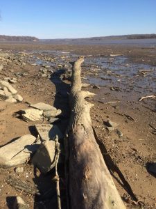
Yesterday’s extreme wind conditions caused what is known as a river blowout.
Water was blown out of the river bed in a domino effect as the Chesapeake Bay and ultimately the ocean lost volume by wind-generated tidal forces.
The best answer we found about why this happens was from Fossilguy.com, who stated, “Blowout tides occur in areas (generally nearshore shallows, marshes and tributaries) where the shore is very flat so the water remains shallow for some distance from the low tide mark. If you get a strong offshore wind at the same time as you have a low tide, then the wind will push the water out to sea so that you have what seems to be an extra-low tide, or a “Blowout” tide (because the wind blows out the water.)”
Today we were literally able to walk on the river bed.
Further downriver in Prince William County the river actually disappeared.
Here are some photos today from the‘ Fairfax County area of postal Alexandria South near George Washington’s Mount Vernon.


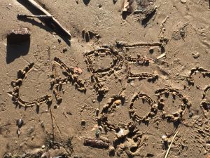


If it’s from Alexandria why does it say cape cod?
Somebody from Cape Cod carved that in the sand is all. The photos are definitely from right here along the GW Parkway.
It strangely resembles Cape Cod now. Clam digging anyone?
To me, it was jokingly written as if they were in Cape Cod where the water there recedes pretty far out, as it did here!
I discovered this about 50 feet from the shoreline. If you have ever travelled to Cape Cod or the Bay of Fundy you will be familiar with this phenomenon. These are among the highest tides in the world.
The water actually disappears with high tide.
It is breathtakingly spectacular.
Yesterday at low tide point when I was walking ON the river I also observed the same patterns in the sand seen on the what is known as The Brewster Flats of Cape Cod’s elbow. The tidal activity is most dramatic in this part of Cape Cod Bay.
We also found lots of shells.
Tennis balls lost by dogs.
One plate.
One small Hippity Hopper ball.
And two reported to Park Police gun shot shells likely from past duck blinds along Little Humting Creek.
Otherwise a spectacularly clean Potomac River.
You may thank Virginia State Senator Scott Surovell who leads regular clean ups of Little Hunting Creek.
But my heeled shoes are a disaster!
Anything for a scoop!!!!
Parting of the Red Sea?
Good time to pick up drift wood for garden or art projects.
Note that the exposed river bottom shown in the photos may actually be part of Maryland! The Maryland-Virginia border is defined as the south shoreline of the Potomac at (normal) low tide.
“Literally”
Where are the snake heads, and vegetation!! ??????